Wednesday, January 30, 2008

Shaligram


The permanent residence of Lord Vishnu


In every big city of India, you will come across advertisements of exhibition cum sale of pearls and other semi precious stones.
In these exhibitions, you will also see rudrakshas, shaligrams and similar objects.
In 1988, almost two decades ago, I visited an exhibition cum sale of pearls in Chennai.
The exhibitor showed me his ware.Statuettes made of crystal; fresh water pearl necklaces; rudrakshas; shaligrams; tulsi malas, etc.
He showed me one shaligram which he said was worth at least 2.5 million Indian Rupees (65,000 U.S. $).
He said he would not sell it at any price because it would bring him good luck and much more furtune.
He later sent me three shaligrams.

At time, I wrote a small article “The sacred Shaligram” in the Hindu.
I got numerous letters.
Some accused me of not knowing anything about shaligrams.
Some wanted me to recommend a good dealer.
My boss read my article and summoned me.
He asked me whether it was true that I was going to accept gift of shaligrams.
I told him I love small gifts and would gladly accept them.
He became very serious.
He said don’t take them unless you can observe the daily rituals strictly.
Otherwise, you would have bad luck.
Although this trait sometimes does create problems, by nature I am very obstinate.
Finally, he made me promise that if I suffered any mishap within a week of getting the shaligrams , I would send them to some nearby temple.
The shaligrams did not affect me in any way.
And they remain with me to this day.
Lord Vishnu has taken good care of himself.

What are Shaligrams

Mythology

According to Hindu religion, God does not reside in any statue.
When we start pooja (worship) of any God (or Goddess), we first have to request that God to enter his statue and remain present for the duration of the pooja.
This is called ‘awahan’ (summon).
After the pooja is over, we have to do ‘visarjan’ (farewell) - request God to go back to wherever he came from.
But shaligram is a special stone in which Lord Vishnu is ever present.
So we have to take extreme care.
Bathe him.
Feed him at regular hours. And perform all the rituals strictly, otherwise…… he may become angry.
Why Vishnu remains in the shaligram?
According to one legend, Vishnu had two wives - Laxmi and Sarswati.
Ladies will always be ladies!
Once the two wives had a big fight.
In a fit of rage, Laxmi cast a curse on Sarswati.
She would have to go down to the earth and live there forever.
Sarswati cried and cried.
When Vishnu came, he told Sarswati not to cry.
He would tay with her on earth.
So Sarswati came down to the earth in the form of Tulsi (Holy Basil) plant and Vishnu came down in the form of shaligram.
Tulsi and shaligram are therefore worshipped together.
According to another legend, Gandaki, a lady devotee, performed sever penance for a long time. She asked for and got a boon from Vishnu, that he would reside in her womb (in her depths) as her own offspring.

What scientists say
According to scientists, shaligrams are fossils of Ammonite - an invertebrate which lived in the Tethys sea which existed between India and the Asian mainland.
There were about a thousand different varieties of ammonites.
Some were coiled.
Other were straight.
All are now extinct.
Their closest surviving ancestor is the pearly nautilus.
As India moved northwards - some 9000 kilometres in 250 million years - the Himalayas were formed.
A number of rivers formed and flowed down from the Himalayas into the Indo Gangetic plain. The shaligram was found in plenty in the Gandaki river.
The photograph of the shaligram here is probably a Perispyinctes of the Jurassic period - about 150 million years old.

Conclusion
Shaligrams are not supposed to be purchased and sold.
They are prized possessions in many Hindu families and are handed down from generation to generation.

The main statues in a few ancient temples are made of shaligram.
What is worshipped is the shaligram stone which has a whorl or chakra.
The one in my photo has a perfect chakra.
And you can also clearly see a serpents hood.
I met the owner again in 2005.
He invited me to inaugurate his new show room in Chennai.
He had indeed accumulated wealth.

The Jagannath Temple, dedicated to Vishnu, in Puri (Orissa) has the largest and heaviest shaligram in India.
The ISKCON temple in Scotland, called ‘Karuna Bhavan’, has the largest number of shaligrams outside India.


So far my own shaligrams are concerned, they have given me no reason what so ever to whimper or complain.
They have indeed kept me happy and content all these years.

Tuesday, January 29, 2008

Badrinath


The Most revered Temple of Lord Vishnu


Visiting Char Dham or the ‘four holy pilgrimages’ - Kedarnath, Badrinath, Gangotri and Yamunotri is every devout Hindu’s dream.


Badrinath also known as ‘Vishal Badri’ is situated on the banks of Alaknanda river - 3,133 metres above sea-level.
This temple is the largest and most popular of the five Badri or Vishnu temples in the Himalayas.

The first time I visited Badrinath was during the initial phases of my training as a civil servant.

Class I officers are selected on the basis of a written examination followed by an interview.
The selected officers comprise an odd assortment - from different regions, with diverse educational backgrounds, coming from different strata of society, representing different cultures, etc.
They are given an orientation training designed to enable them to mix with each other and adjust into the elite bureaucratic set up.
It seems rather strange that the training never did me any good.
Till my last days in service, I could never feel myself any different from the ordinary man.
I was and remained a commoner.
My office was open to everyone and sundry.
I never left my office without meeting the last visitor.
As a part of their training, new entrants to the civil services are sent to different parts of the country.
To see things - first hand!
We were sent to Badrinath and Kedarnath.
The program included a visit to the Jawans (Indian army) in the Mana pass.
From Joshimath, military vehicles and escorts took us into the heights of the Mana village and then onwards to the military camp.
The commander there had arranged a mock battle for us.
Two groups of soldiers fought against each other as they would in real war.
Machine guns rattled.
Shells burst and dense smoke billowed.
There were mock attacks.
The soldiers shrieked and shouted and even fell down stone dead as if they had been hit by a bullet.
The soldiers did their best to show off their acting talents.
And they succeeded.
The battle looked very realistic.
I started taking photographs of the mock battle.
A soldier came up to me, reminded me that we were in a prohibited forward area and asked me to stop.
The Commander (a lieutenant colonel) who was watching from a distance immediately stepped in, asked what the problem was, and gave the green signal. “Go ahead. Sir”, he said.
We tasted the normal lunch which our jawans usually have in the high altitude border areas.
I have visited Badrinath twice after that.

Mythology
Badrinath is mentioned in the Hindu ancient texts.
There was an ancient temple here during the ancient times.
Although the statue is very old, the present temple was built recently.
The statue of Lord Vishnu in Badrinath temple is made of Shaligram stone.
It is in the padmasana or sitting pose.
One legend explains why Vishnu’s statue is in the padmasana pose, rather than in the usual reclining pose.
A sage saw Lakshmi (Vishnu’s wife) massaging the feet of Vishnu.
He rebuked Vishnu.Vishnu came down to Badrinath to perform austerity and meditated for a long time in padmasana pose.
The area around Badrinath attracts yogis who come here for meditation and seclusion.

Another legend says that Shiva and Parvati were residing in Badrinath.
Vishnu came disguised as a small child, crying loudly and disturbed them.
Parvati asked the child why he was crying.
He replied that he wanted Badrinath for meditation.
Shiva and Parvati recognised Lord Narayan in disguise.
They left Badrinath and moved over to Kedarnath.

Adi Shankarachary visited Badrintah in the 8th century.
He retrieved the statue of Badrinarayan from the Alaknanda River where it had been thrown away centuries ago and installed it in a cave near the Tapt Kund hot springs.
The King of Garhwal established the present temple in the sixteenth century.
The temple was badly damaged by the earthquake of 1803.
It was then rebuilt by the Maharaja of Jaipur.

Some authors claim that the temple was built on a former Buddhist temple site.
The Temple

Badrinath temple is flanked by two mountain ranges known as Nar and Narayan.
The majestic Neelkanth peak provides a befitting backdrop.

This area was once carpeted with wild berries which gave it the name ‘Badri Van’, meaning ‘forest of berries’.

The statue of Lord Vishnu is made of Shaligram and depicts him sitting under a badri tree under a gold canopy.

There are fifteen more statues in the temple including statues of Nara & Narayana, Narasimha (the fourth incarnation of Vishnu), Lakshmi, Narada, Ganesha, Uddhava, Kubera, Garuda (the vehicle of Lord Narayan) and Navadurga.

Facing the temple at the bank of Alaknanda river is a hot water spring known as ‘Tapt Kund’. It is supposed to have medicinal properties and curative powers.A bath in this spring is very refreshing. There is a separate tank for women.


Time to Visit

Badrinath is too cold and inaccessible during the winter months.
The temple is closed in November and the statue is moved to nearby Jyotirmath .
The best time to visit Badrinath is between May and October.

General Information

Rail
The nearest station is Rishikesh (293 kms).
Road
Badrinath is connected by road to Rishikesh (293 km), Haridwar (313 km), Kotdwara (325 km), Joshimath (42 km) & Valley of flowers (38 km), Kedarnath (242 km) and Delhi(518 km).

Places of interest

· Mana Village (3 kms) - the last Indian village near the Indo-Tibetan border. Even today, the traditional people here maintain their own way of life.
· Bheem Bridge - this is a natural bridge over the river Saraswathi, near Mana Village, made of a huge boulder.
· Vasudhara Falls - this is a high waterfall 5 kms after Bheem Bridge.
· Satopanth Lake - this beautiful lake full of lotus flowers is 18 km from Mana Village.
· Pandukesar (20 kms) - this is a memorial for the Pandavas. There are two ancient temples with intricate carvings.
· Govind Ghat - 2 kms before Pandukesar, this is the gateway to the Hem Kund Lake and the fabulous Valley of the Flowers. The Hem Kund is 20 kms by foot from here. The Valley of the Flowers is a 17 kms walk.
· Hanuman Chatti - 13 kms before Badrinath - this is a temple. Nearby is a nursery of rare birch trees.
· Kheerau Valley - when you cross the bridge on the Alaknanda River on the way from Hanuman Chatti to Benakuli, you see this extremely beautiful valley. 4 kms from here is the Kheerau village.
· Joshimath (42 kms) - Adi Shankaracharya visited this place in the 18th century and founded the Mutt called Jyotir math or Joshimath.


My recommendation

The statue is considered to be one of eight swayam vyakta keshtras, or self-manifested statue of Vishnu.

A peculiar feature of this temple is that in accordance with the practice started by Adi Shankaracharya, the Rawal, or head priest of this temple, is a Nambudiri Brahmin from Kerala (south India).
Visit the place.
The journey is most enjoyable.
You will forget the hustles and bustles of city life and get immersed in a world of peace and tranquility.

Sunday, January 27, 2008

Kedarnath Temple


Jyotirlinga Shrine

Visiting Char Dham or the ‘four holy pilgrimages’ - Kedarnath, Badrinath, Gangotri and Yamunotri is every devout Hindu’s dream.

Kedarnath

Perched at the head of Mandakini river, 3584 metres above sea level, the Kedarnath Temple is the most important Hindu temple in the Himalayas.
It is also one of the most important Shiva temples in India.

I have visited Kedarnath twice.
The second time, it was in the month of June.
We travelled by car from Delhi via Dehradun and Mussourie.
We reached Gaurikund (14 kms from Kedarnath) around 4 P.M.
The road passes through beautiful mountains.
At times, you can see a river snaking far below.
And you pass over frail looking bridges.
From Gaurikund, you can either walk up, be carried in a basket (for youngsters and aged), hire a palanquin, or ride a pony.
I wanted to walk up.
But since it was getting late, I was coerced into hiring ponies.
The scenery was extremely beautiful.
But the pony tracks were far too narrow, at times just sufficient for a single pony.
On one side of the track would be the mountain face.
On the other, a steep vertical fall.
And whenever I looked down, I was reminded…. that if…..……. the pony slipped, I would land thousands of feet down.
I had never seen a snow fall.
I was hoping we would see snow fall.
But the pony owners told us it was too late for that.
Just two kilometres short of Kedarnath, the sky started turning dark.
Visibility fell rapidly.
And we were covered with what we felt were fluffs of soft cotton.
But these were not fluffs of cotton, but beautiful flakes of snow.
In a few minutes, the sky became completely dark.
We could not see anything beyond a few inches.
Visibility was zero.
Our hands started freezing.
We were just one kilometre from Kedarnath.
Our pony owners told us we must stop.
Because one slip in the darkness meant certain death.

There were no hotels on the way. Mere ‘chattis’ - small shops made of roughly hewn stones stacked on top of one another - where one can have tea, coffee and simple vegetarian meals.
They also keep blankets, pillows, etc. for a night stay.
Even today, some pilgrims prefer to walk the 14 kms.
And they spend the nights in these ‘chattis’.

So we entered a ‘chatti’.
The crackling log fire was more welcome than any five star luxury.
We had some hot tea followed by some good simple meals.
The snow on our clothes melted.
We had not carried any extra clothes.
So we had to take off most of our clothing and hang them up to dry.

There were no beds.
The ground was rocky and uneven.
Icy winds blew in through the holes and crinks between the stones.
We squeezed into some blankets huddling to each other like penguins.
A little past midnight, I ventured outside in my undergarments.
I was in fairy land!
The scene was so enchanting, I did not feel the cold.
All around were beautiful ice clad blue mountains I had read about in fairy tales.
There was no moon, yet visibility was good.
It was one scene, I have never seen again.

Mythology

According to mythology, after the Pandavas defeated the Kauravas in the Kurukshetra war (Mahabharat), they felt guilty of having killed their own brothers and sought the blessings of Lord Shiva to repent for their sins.

But Lord Shiva did not want to bless them and evaded them repeatedly.
Finally, Lord Shiva took refuge at Kedarnath in the form of a bull.
The Pandavas followed him…… relentlessly.
At Kedarnath, Lord Shiva dived into the ground to hide, leaving only his hump on the surface.
The stone hump is the form in which Lord Shiva is worshipped in Kedarnath temple.

The remaining portions of Lord Shiva appeared in four other nearby places and are worshipped there as his manifestations.
The arms appeared at Tungnath; the face at Rudranath; the belly at Madhmaheshwar; and his head with locks of hair at Kalpeshwar.
Kedarnath and these four shrines (Tungnath, Rudranath, Madhmaheshwar and Madhmaheshwar), where different parts of Lord Shiva appeared, are known as Panch Kedar.

There are five holy peaks here. Rudra Himalaya, Vishnupuri, Brahmapuri, Udayagiri -Kanha and Swargarohini.

Swargarohini (meaning Road to Heaven) was used by the Pandavas and Droupadi to reach heaven.
Arjuna did severe penance here to please Lord Shiva and get Pasupata, the most potent weapon.
The Temple
According to mythology, the Pandavas built the original temple at Kedarnath.
Adi Shankaracharya visited Kedarnath during the 8th century A.D. and he built the present temple.
Adi Shankaracharya took his Samadhi in Kedarnath at the young age of 32.
His Samadhi lies just behind the temple.
Beyond this sketchy detail, we don’t have any indication about who built the temple and when.
The present temple is built of large grey stone slabs.
The temple has a ‘Garbha Griha’ the sanctum sanctorum, which contains the image of Lord Shiva in the form of a stone hump (a conical rock formation measuring about five feet by four feet);and a Mandap where pilgrims and visitors gather.
In this form, Lord Shiva is known as Lord Maheswar-Kedareswar

The inner walls of the assembly hall are decorated with figures of various deities and mythological scenes.
Just outside the temple door is a huge and beautiful statue of Nandi (the Bull), Lord Shiva’s vahan.
Time to Visit
Kedarnath temple is surrounded by high mountains.
During the winter months, it is impossible to reach Kedarnath.
In November, Lord Shiva, is carried down from Kedarnath to Ukhimath; and is brought back to Kedarnath in the first week of May.
It is believed that Lord Shiva is worshipped by the lesser gods for six months and the rest of the year by the humans.

May to October is the best season to visit Kedarnath.

Places of Interest

· Chorabhari Tal or Gandhi Sarovar (3 kms).
· Gaurikund (14 kms) - hot springs of medicinal values and a temple dedicated to Gauri.
· Vasuki Tal (6 kms) – this beautiful lake is 4135 m above sea level.
· Triyuginarayan (5 kms from Son Prayag) - this is the mythological place where Lord Shiva married Parvati.
· Gupt Kashi (49 kms) - famous for the temples of Ardhnarishwar and Vishwanathji.
· Ukhimath (60 kms) - winter home of Lord Kedarnath, and the seat of the Rawal (Priest) of Kedarnath during the winter months.
· Panch Kedar - the five most important temples of Lord Shiva in the Garhwal Himalayas.
· Chopta (40 kms from Gopeshwar) - one of the most picturesque spots in the entire Garhwal region. It provides a breathtaking view of Himalayan ranges.
· Deoria Tal - in the early morning, the snow-capped peaks are clearly reflected on the waters of this lake on the Chopta - Ukhimath road.
· The Kedar Massif - is an outstanding massif formed by three major mountains.

Reaching there
Rail
The nearest station is Rishikesh (221 kms).

Road
Kedarnath is connected by road with Delhi (450 km), Haridwar (250 km), Rishikesh (226 km), Kotdwara (256 km), Badrinath (242 km).

Accommodation
Plenty of reasonably good accommodation is available in Kedarnath.
My recommendation

Kedarnath is one of the twelve Jyotirlingas of Kedar or Lord Shiva.
Even if you are not interested in religion and temples, do visit the Char Dhams.
They are really beautiful places to visit.

Saturday, January 26, 2008

Panhala Fort


Guardian of the Western Ghats


Panhala is a beautiful hill station - 977.2 metres ( 3177 feet) above sea level - about 18 km north-west of Kolhapur in the state of Maharashtra.

The most interesting thing here is Panhala Fort – the largest of the Deccan forts.

The Fort is strategically located on one of the principal routes passing through the Western Ghats and was therefore of great military importance. It is also intimately connected with Shivaji and the Maratha rule.

History

Panhala Fort was built by the Shilahara ruler King Bhoja II between 1178 and 1209 A.D. Subsequently, it passed into the hands of the Yadav rulers.

This fort was a favorite outpost of the Bahamanis of Bidar.

By the beginning of the 16th century, Panhala became a part of the kingdom of Bijapur. The Adil Shahis strengthened and rebuilt the ramparts and gateways.


Shivaji attacked the fort in 1659. But he could occupy it permanently only in 1673.


Shivaji did not stay in any single fort for a long time.Panhala is the only fort where he spent more than 500 days, other than his childhood homes.


Shivaji imprisoned his errant son Sambhaji in this Fort in the building known as Sajja Kothi, Sajja Kothi was built by Ibrahim Adil-Shah in 1500 AD.

But Sambhaji escaped... right into the arms of his father’s enemies.


It was here that Shivaji beleaguered for over four months and escaped on a rainy night to Vishalgad, while his loyal general Baji Prabhu Deshpande laid down his life, holding down the forces of Siddi Johar at a narrow pass.
This place is now called Pavankhind.

In 1701, Panhala was surrendered to Auragzeb, and it was here that the Mughal Emperor received the English Ambassador, Sir William Norris.
Within a few months the fort was taken back by the Maratha forces.

Panhala was the Maratha capital until 1782, when the capital was shifted to Kolhapur. After a local rebellion in 1844, Panhala was taken over by the British.

Fort

The Fort is built on an outlying spur of the Sahyadris, rising more than 400 metres above the surrounding plains. From the fort, you can see the plains for miles around.

More than 7 kms of fortifications encircle the Panhala Fort.
The walls are protected by steep escarpments, reinforced by a parapet with slit holes.
The remaining sections have 5 to 9 metres high ramparts, strengthened by round bastions.
The East Gate called Char Darawaja, through which the road passes on arrival at the Fort, was demolished by the British.

Places to see in Panhala

Amberkhana or Granary

There are three large buildings called Amberkhana - a huge granary - with the capacity to store 50,000 pounds of corn, sufficient to last an entire army for several months.

Sajja Kothi
The Sajja Kothi was actually a pleasure pavilion set into the ramparts.
This two storied structure has an upper chamber with rather flatish domes on vaults decorated in typical Bijapur style.
An arcaded balcony on the west looks down into the fort.
The chamber on the east gives a panoramic view of the approach to Panhala from the plains beneath.

Other places
Nearby are the Sambhaji temple; Someshwar temple; Teen Darwaza; Raj Dindi; Ambabai Temple where Shivaji used to seek blessings before going out on his many expeditions; and Pavankhind, where Baji Prabhu Deshpande laid down his life to cover Shivaji's escape.

Places to see around

Kolhapur is a lovely place with many things to see.

Reaching There

Air

Air Deccan has daily flights from Mumbai and Bangalore.

Train

Kolhapur is well connected to Mumbai, Pune, Bangalore and Miraj by rail.

Road

Kolhapur to Mumbai is 396 kms
Kolhapur to Bangalore is 600 kms

Kolhapur lies on National Highway 4 which connects Mumbai to Bangalore.
Mumbai to Kolhapur is about 6 hours drive by road.
The road is very good.

Friday, January 25, 2008

Ellora


The rock cut caves of Ellora


In my earlier blog on Ajanta, I have already written that Government service does provide some unique pleasures and opportunities.

I have thanked the Election Commission of India which sent me as an election observer to Buldana (Maharashtra).

This spell of duty made it possible for me to see the Lonar Crater, Aurangabad, Ajanta, Ellora and vast areas completely devastated by earth quakes.

The caves of Ellora represent the epitome of Indian rock-cut cave architecture.


Caves of Ajanta and Ellora – Differences

There are two basic differences between the rock-cut caves of Ajanta and Ellora.

The caves of Ajanta were covered by vegetation and debris and lost between the pages of history.
They were ‘re-discovered’ in 1819 by a group of British Officers of the Madras Army.
On the other hand, Ellora was continuously visited by pilgrims, tourists and travellers, right up to the present day.

Secondly, all the caves of Ajanta are connected to the Buddha and Buddhism.
But the caves of Ellora encompass three religions - Buddhism, Hindu and Jain.


The Caves of Ellora

There are a total of 34 caves excavated out of the vertical cliffs of the Charanandri hills.

These comprise of Buddhist, Hindu and Jain cave temples and monasteries excavated during different periods of time spanning across six centuries.

Of the 34 caves:

· 12 are Buddhist caves - excavated during the 5th to 7th century A.D. (Cave nos. 1 - 12 at the southern end).
· 17 are Hindu caves - excavated during the 8th to 10th century A.D. (Cave nos. 13 - 29 in the middle, and
· 5 are Jain caves - excavated during the 9th and 11th century A.D. (Cave nos. 30 - 34 at the northern end).


The Buddhist Caves

The Buddhist caves are the earliest in point of time. They were excavated between the fifth and seventh centuries.

Just like the Ajanta caves, the caves here consist of two types of excavations - viharas (monastic halls of residence) and chaitya grihas (stupa or monument halls).


Of the 12 Buddhist caves, all except Cave no. 10, are viharas - large, multi-storeyed buildings carved into the mountain face, which include living quarters, sleeping quarters, kitchens, etc.


The last two Buddhist caves, Do Tal (Cave no. 11) and Tin Tal (Cave no. 12) are viharas having three storeys each.


Some of these viharas have shrines, and carvings of Buddha, bodhisattvas

and saints.
In many of the caves, the stone has been sculpted to give the appearance of wood.

The most famous Buddhist cave is Cave no. 10, a chaitya griha (chandrashala) or ‘Vishwakarma Cave’, popularly known as the ‘Carpenter’s Cave’.

When you enter the multi storeyed entrance of Cave no. 10, you come into a large hall, whose ceiling has been carved to give the impression of wooden beams.

And there is a 15 foot statue of Buddha seated in a preaching pose.


The Hindu Caves


The Hindu caves were constructed in the beginning of the 7th century and represent a complex mix of creative art and execution skills.

The Kailash Temple, Cave no. 16, is the grandest and undisputed masterpiece of Ellora.
It is the largest monolithic structure in the world.

Construction of this cave involved removal of 200,000 tons of rock and took 100 years to complete.
It is a feat of creative human genius.


This gargantuan structure depicts Mount Kailash, the abode of Lord Shiva.
It looks like a free standing, multi-storeyed temple complex.
But it was actually carved out of one single rock, and covers an area double the size of the Parthenon in Athens.


All the carvings were done in more than one level.
A two-storey gateway leads into a U-shaped court yard.
The court yard is edged by three storeys high, columned galleries.
The galleries have huge sculpted panels; and alcoves containing enormous sculptures of a variety of deities.
Originally, flying stone bridges connected these galleries to the central temple structures, but these have since fallen away.


The main temple has a Shiva linga.
In front of this linga, is an image of the sacred bull Nandi.

The base of the temple is carved to suggest that elephants are holding up the structure.

Most of the deities at the left of the entrance are Shaivaite (followers of Shiva); while on the right hand side, the deities are Vaishnavaites (followers of Vishnu).

The temple is a splendid specimen of Dravidian art.
Its excavation was started by Krishna I (757 A.D. - 773 A.D.) of the Rashtrakuta dynasty that ruled from Manyakheta in the present day Karnataka state.
Krishna I’s rule had spread to southern India.

Therefore, this temple was excavated in the prevalent Dravidian style.
Its builders modelled the temple on the lines of the Virupaksha Temple in Pattadakal.

Other notable Hindu caves are the Dashavatara Cave, Cave no.15, which depicts the 10 incarnations of Vishnu; the Ramesvara Cave, Cave no. 21, which has figurines of river goddesses at the entrance, and the Dhumar Lena Cave, Cave no. 29, which is the oldest excavation and whose design is similar to the cave temples on Elephanta Island in Mumbai.


The Jain caves

The Jain caves are simple and reflect asceticism.
Compared to the other caves, they are small, but they have exceptionally detailed art work.

For example, Cave no. 32, Indra Sabha is a shrine with a very fine carving of a lotus flower on the ceiling.
In another cave, an imposing yakshini is sitting on a lion under a mango tree, laden with fruits.

All other Jain caves also have intricate details.

Many of the structures had rich paintings in the ceilings - fragments of which are still visible.


My recommendation

Ellora is 30 km from Aurangabad in the state of Maharashtra.
It was known as Verul in ancient times.

Ellora is a World Heritage Site.
Its temples will always remind us that the rulers of those days were tolerant of all religions.

And that is the essence of Hindu religion.

Wednesday, January 23, 2008

Ajanta


The Rock cut Caves of Ajanta


Government service does provide some unique pleasures and opportunities.
I must thank the Election Commission of India which sent me as an election observer to Buldana (Maharashtra).
I saw the Lonar Crater, Aurangabad, Ajanta, Ellora and vast areas completely devastated by earth quakes.
Ajanta Caves
The rock cut caves of Ajanta and Ellora in Maharashtra represent the ultimate in this type of cave architecture.
The Ajanta caves are older of the two - being over 21 centuries old.
The Ellora caves are some 6 centuries younger.

Location
The Ajanta caves were discovered in 1819 by a group of British Officers of the Madras Army. The officers accidentally stumbled upon the caves hidden amongst dense vegetation and buried under debris.
After that, the Archeological Survey of India started excavations.

These caves are located in a thickly forested horseshoe shaped ravine in the Sahyadri hills, 3½ km from the village called Ajintha, about 105 kilometers from Aurangabad.
The Waghur river runs at the bottom of the ravine.

Period of Excavation
There are 30 excavated caves in Ajanta.Cave nos. 1 to 29 and Cave no. 15A (the last one was discovered in 1956, and is still not officially numbered).
They are located about 35 to 110 ft. above the level of the river.
The first Buddhist rock-cut cave monuments at Ajanta date from the 2nd and 1st centuries B.C.
During the Gupta period (5th and 6th centuries A.D.), many more richly decorated caves were added to the original group.
The excavations of the caves were done in two distinct phases.
The first phase is called the Hinayana phase (referring to the Lesser Vehicle tradition of Buddhism, the earlier phase, when Buddha was revered symbolically).
Actually, Hinayana - a derogative term for Sthaviravada - does not object to Buddha statues.

Cave nos. 9, 10, 12, 13, and 15A were excavated during this phase.
These excavations have enshrined the Buddha in the form of the stupa, or mound.
Cave no. 8 was for long thought to be a Hinayāna cave.
Now it is treated as a Mahayana cave.

The second phase of excavation began after three centuries.
This phase is called the Mahayana phase (referring to the Greater Vehicle tradition of Buddhism, which is less strict and encourages direct depiction of Buddha through paintings and carvings).
This phase is also called the Vakataka phase after the ruling dynasty of the house of the Vakatakas of the Vatsagulma branch.
None of the caves in the Vakataka phase were ever fully completedbecause the Vakataka dynasty suddenly fell out of power which brought the activities at Ajanta to a complete halt.

Two Types of Structures
The Ajanta caves consists of two types of excavations - viharas (monastic halls of residence) and chaitya grihas (stupa or monument halls).
Cave nos. 9, 10, 19, 26 and 29 are chaitya grihas.
The others are viharas.
The caves contain paintings and sculptures considered to be masterpieces of both Buddhist religious art and universal pictorial art.
There are paintings on the walls in Cave nos. 1, 2, 16 and 17 that are clear and vibrant even today.

All the paintings in the caves are linked to religion and centre around the Buddha.
They illustrate events in the life of Prince Gautama Buddha; incidents from the life of the Buddha; and the Jatakas (stories pertaining to Buddha’s previous incarnation).

Frescoes and murals

The paintings are often referred to as “frescoes”.
But the proper term for this kind of art work is “mural”, because the technique of fresco painting has not been used in Ajanta.
The technique used to produce the paintings at Ajanta is unique.
It is unlike any other artwork found in any other civilization.
The paintings give us a glimpse of the life style during that period - hair styles, ornaments, textiles, musical instruments, details of architecture, customs, etc.
My recommendation
It is difficult to believe that the beautiful caves and the carvings in the caves could have been chiselled out of granite rocks only with hammer and chisel.
The paintings were also done with very simple and basic material.
A particular type of classical Indian art started and developed in Ajanta.
This style traveled with Buddhism to many other countries - Sigiriya in Sri Lanka, Bamiyan in Afghanistan, Tibet, Nepal, China and Japan.

In 1983, the Ajanta Caves were declared a UNESCO World Heritage Site.
These are must see places for everyone.

Tuesday, January 22, 2008

Aurangabad & Daulatabad


What is there to see in a small non-descript place like Aurangabad?
You must visit the place to find out.
Two Mughal Emperors visited the region, and they liked it so much that they shifted their capital from Delhi to this region.
The Daulatabad Fort, which is one of the world’s best preserved forts of medieval times, alone would make Aurangabad a great place to visit.
But there is far more to see.
Because Aurangabad is also the gateway to the world famous rock cut caves of Ajanta and Ellora.

Aurangabad or Daulatabad

The two terms are indiscriminately used, as if they represent the same place.
But Aurangabad and Daulatabad are two different cities.
Of the two cities, Daulatabad is far older and at a distance of 16 km. from Aurangabad.
Today, the ruins of Daulabad remain just a reminder of its glorious past, while Aurangabad is one of the major cities of Maharashtra with a number of industries.
Daulatabad (old Devagiri)

The ancient city of Devagiri (from deva giri - meaning Hill of the Gods), the old name for Daulatabad, was founded in 1187 by Bhillama V, a king who renounced his allegiance to the Chalukyas, and established the Yadava dynasty in the west.
He also built a fort in Devagiri.
The present Devagiri Fort was constructed later - during the reign of Singhana II (1210 - 46 A.D.).
Devagiri was captured by Ala-ud-Din Khilji in 1307 A.D., marking the first Muslim invasion of the Deccan (South India).
In 1318 A.D., Malik Kafur killed the last Yadava Raja, Harapal.
Because of its strategic location, in 1327 A.D., Muhammed-bin-Tughluq decided to shift his capital from Delhi to Devagiri.
He changed the name of Devagiri to Daulatabad (from daulat bad meaning City of Fortune); and ordered his entire army, the royal household, ministers, advisors, scholars, poets, musicians and others to move from Delhi to Daulatabad.
The people of Delhi did not want to move out to a new place. Muhammed-bin-Tughluq was very angry and ordered everyone including cats and dogs to move.
Within two years, Muhammad decided to return back to Delhi and ordered a return march which very few survived.
The colossal loss in terms of number of lives lost and the money wasted reduced the prosperity and grandeur of Delhi.
In 1607, Daulatabad passed into the hands of the Nizam Shahi minister, Malik Amber, a usurper, originally an Abyssinian slave, who founded Kharki (the present Aurangabad).
His successors held Daulatabad until their over throw by Shah Jahan, the Mughal emperor, in 1633.
Daulatabad remained in the possession of the Delhi emperors until the death of Aurangzeb, the sixth and last Mughal Emperor.
Therafter, it fell to the first Nizam of Hyderabad.

However, the glory of Daulatabad started declining after the 17th century when Mughal Emperors shifted the seat of government to Aurangabad.

Daulatabad Fort

The Fort is strategically located on a pyramid shaped hill, 600 ft above the Deccan plain.
The Fort was constructed on the remains of a Buddhist monastery and signifies unique military engineering planning skills.
The main features of this Fort are:

· A thick outer wall, 6 kms in circumference, which encircled the entire city of Devagiri, including the magnificent Devagiri Fort. This provided the first line of defense.

· Three concentric lines of massive walls with large number of bastions which provided unparalleled defense fortifications.

· The lower slopes of the hill were sliced away by the Yadava rulers to carve out a 50 meter vertical drop so that no hostile troops could clamber up.

· The walls are surrounded by a 40 ft. deep moat. The moat was filled with water and had a large number of crocodiles. There were mechanical draw bridges.

· Long sub-terranean passages hewn out of solid rock.

· The inner walls had heavy iron gates fitted with large iron spikes to deter the use of elephants for ramming the gates open.

· The upper exit of the passage was filled with an iron grating, on which a large fires could be lighted to prevent the progress of the enemy.

· The summit could be reached only by a narrow bridge, which was wide enough for two persons only.

The impregnable Fort could never be conquered in a straight battle. It was always taken over through deceit and treachery.

Other monuments in Daulatabad

Daulatabad contains several remarkable monuments.
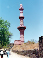
The chief of them are the Chand Minar and Chini Mahal.
The Chand Minar was erected in 1445 by Ala-ud-din Bahmani to commemorate his capture of the Fort.
It is a tower 210 ft. high and 70 ft. in circumference at the base.
It was originally covered with beautiful Persian glazed tiles.
It reminds one of the Kutub Minar in Delhi.

Opposite the Minar is the Jumma Masjid (Friday Mosque), whose pillars originally belonged to a temple.
Close by is a large masonry tank.

The Chini Mahal, or China Palace, is the ruin of a very beautiful building.
Abul Hasan, the last Qutb Shahi king of Golconda, was imprisoned by Aurangzeb in this building in 1687.
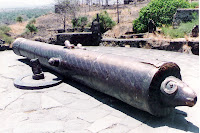
Nearby is a round bastion topped with a huge canon with a ram’s head, called Kila Shikan or Fort Vanquisher
Aurangabad

Malik Ambar, the Prime Minister of Murtaza Nizam Shah II, of Ahmednagar, the then ruler of the Deccan founded Aurangabad between 1604 and 1610.
Before that, the site was a village called Kirki (or Khadki).

Initially, the city was named Fatehpura (from fateh pur meaning City of Victory), or after Malik’s son Fateh Khan.
In 1634, Aurangzeb came to Kirki as Governor of Deccan.
Ten years later, Aurangzeb moved over to Agra to play a more active role in Mughal politics.

In 1681, the city again became the residence of Aurangzeb, who had now become the Mughal Emperor.
Aurangzeb shifted the capital from Delhi to Aurangabad.
Till his death in 1707 AD, Aurangzeb used the city as a base for his campaigns against the southern kingdoms.
Fatehpura was renamed Aurangabad, after Aurangzeb, sometime during this time.

Aurangzeb lies buried in Khuldabad, a small town near Aurangabad.
What to see
Bibi ka Maqbara
The Bibi ka Maqbara was built by Emperor Aurangzeb’s son Azam Shah in 1678, in memory of his mother, Begum Rabia Durani.
The white marble monument is a replica of the world famous Taj
Mahal of Agra.

Panchakki

The Panchakki, or water mill, was built by Malik Ambar in 1695.
Water, channeled from a spring in a distant hill, was used to power the mill to grind grain for the pilgrims.

Darwazas
There are four main darwazas (or gates) leading into the city and nine secondary darwazas which formed part of the defense system of Aurangabad.

Aurangabad Caves
Aurangabad has a group of 10 beautiful Buddhist caves just outside the city.
These caves are artificial in the sense they are not natural but were dug out of the soft rock during the 6th and 7th century.

These caves are found on two separate locations, called Western Group Caves (Caves 1 to 5) and Eastern Group Caves (Caves 6 to10) about 1km from each other.
Cave 6 of the Eastern Group has well preserved sculptures of women, with exotic hairstyles and ornamentation.
Cave 7 is the most interesting of the Aurangabad caves.
There are sculptures of scantily dressed women with ornaments and jewels.

Khuldabad

Khuldabad (or the Abode of Eternity) is just a few kilometers from Daulatabad.
In the 14th century, several Sufi saints of the Chishti order, settled down here.
The dargah, or tomb of Moinuddin Chishti, the spiritual guru of the Mughal emperor, Aurangzeb, is in this sacred complex.
Emperor Aurangzeb lies buried nearby in a simple grave as he had wished during his lifetime. His tombstone bears the inscription: “No marble sheets should shield me from the sky as I lie there one with the earth.”

Getting there
Air
Aurangabad has an airport 10 kms from the town.
There are direct flights connecting Aurangabad with Mumbai, Delhi and other Indian cities.
Rail
Aurangabad is well connected to Delhi, Mumbai and other cities.

Road
Aurangabad is about 375 kms from Mumbai.

My Recommendation
Make a full week program and visit Aurangabad, Dalulatabad, Ajanta and Ellora in a single trip. The world famous caves of Ajanta and Ellora are World Heritage Sites.
The summers are hot.
Therefore, the best time to visit these places is between September to early March.